DJI Zenmuse P1
DJI Zenmuse P1 is an accurate and efficient drone photogrammetry payload for the DJI M350 RTK and M300 RTK.
Enhanced Drone Photogrammetry The P1 integrates a 45MP full-frame sensor with interchangeable fixed-focus lenses to build detailed 2D maps and 3D models.
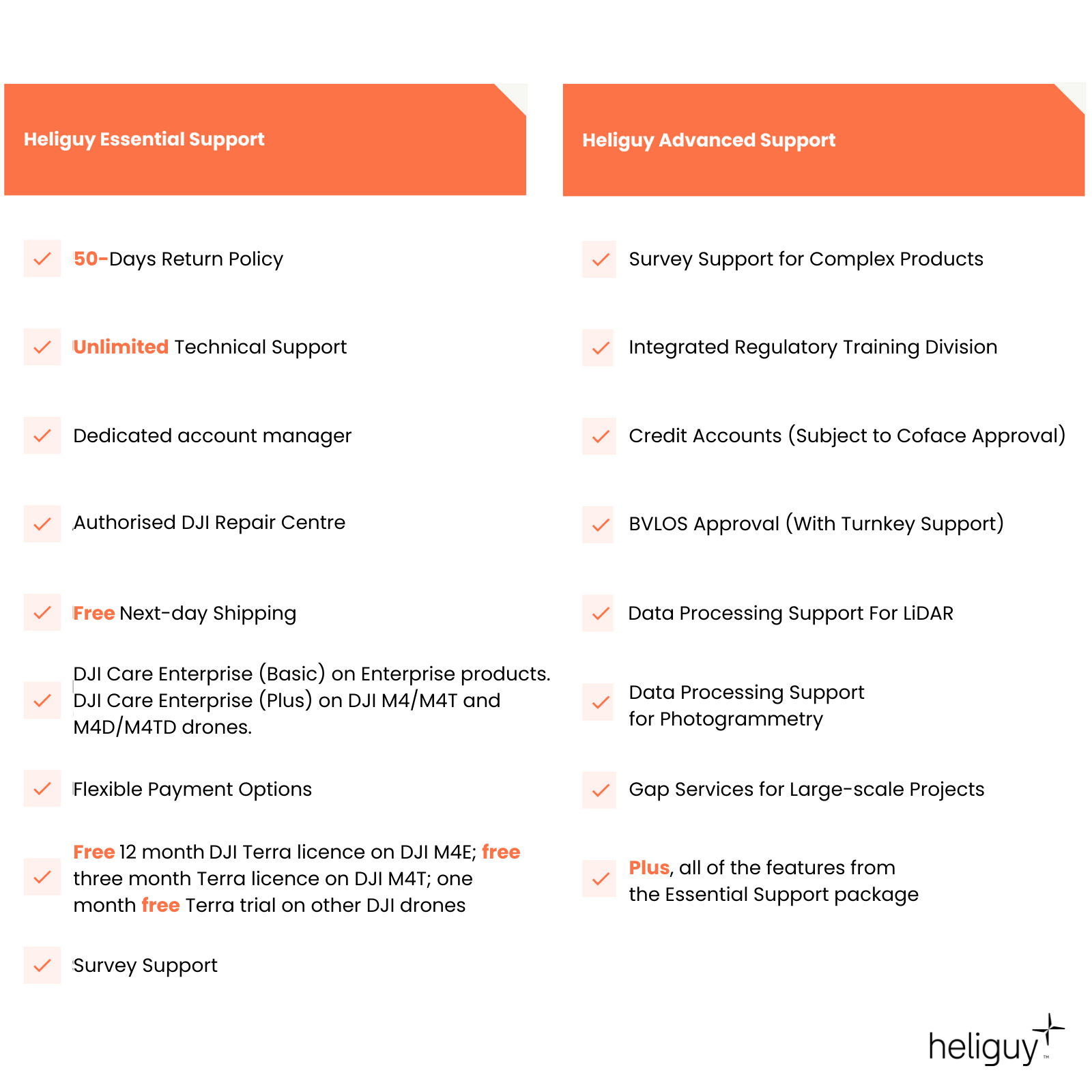
Survey Support Access end-to-end P1 workflow advice from our in-house geospatial specialists, from data capture through to processing.
DJI Care Enterprise Included as standard, DJI Care Enterprise (Basic) entitles you to two replacements in the first year for a fee.
- Overview
- Contents
- Specifications
- Support
- FAQ
- Heliguy Services
DJI Zenmuse P1 Key Features
High-Precision Drone Photogrammetry
45MP Full-Frame CMOS: Provides high-resolution imaging for detailed and accurate data capture.
High Accuracy: Achieves 3 cm horizontal and 5 cm vertical accuracy without ground control points, using a 75% front overlap ratio and 55% side overlap ratio.
3-Axis Stabilised Gimbal: Features Smart Oblique Capture for stable and precise imaging, even during dynamic movements.
High Efficiency: Covers up to 3 km² in a single flight with 3 cm GSD, 75% front overlap, and 55% side overlap, maximizing coverage and operational efficiency.
Mechanical Global Shutter: Utilises a mechanical leaf shutter with a 1/2000s shutter speed for clear, blur-free images.
TimeSync 2.0: Synchronises the flight controller, RTK, gimbal, and camera within milliseconds, ensuring precise coordination and data accuracy.
High-Resolution Mapping Camera
Detailed and Accurate Drone Survey Data
Full-frame Camera: DJI Zenmuse P1 has a 45MP full-frame sensor with a 4.4μm pixel size and a 0.7s shooting interval. Low-noise, high-sensitivity imaging extends daily operational time.
TimeSync: TimeSync 2.0 aligns the camera, flight controller, RTK module, and the gimbal at the microsecond level. This helps P1 capture centimetre-accurate data combined with the real-time position and orientation compensation technology.
Multiple Lens Options: The P1 integrates with 24mm, 35mm, and 50mm fixed-focus lenses for operational flexibility. The lenses feature a global mechanical shutter, with a shutter speed of 1/2000 seconds.

Smart Oblique Capture
One camera. Multiple angles.
Multi-Angle Photography: Capture multiple angles with a single camera using Smart Oblique Capture, allowing for diverse and detailed imaging in one efficient flight.
Smart Oblique Capture: Enhances the efficiency of oblique photography by automatically rotating the gimbal to capture photos from different angles, ensuring comprehensive coverage.
Optimised Edge Photography: Takes only essential photos at the edges of the flight area, reducing unnecessary data and increasing post-processing efficiency by 20% to 50%.

Data Outputs
Highly-detailed visualisation
2D Orthomosaics: Generate orthomosaics without GCPs, perfect for medium to large-area operations.
3D Oblique: Effortlessly acquire oblique images from multiple angles that meet 3D modelling requirements across industries such as urban planning and centimetre-level accurate cadastral surveys to serve 3D reality models and smart city planning.
Detailed Reconstruction: High-resolution data images can be obtained efficiently, to help restore the fine texture, structure, and characteristics of the ground and objects. This is ideal for building reconstruction, heritage site conservation, water conservancy engineering, and geological surveys.

Seamless Drone Survey Workflows
Utilise the DJI ecosystem for end-to-end mapping solution
DJI Ecosystem: Provides an end-to-end survey workflow, from flight planning and data capture through to processing.
Data Capture: Plan the mission using the DJI Pilot app, which offers various flight options. Deploy the DJI M300 RTK or DJI M350 RTK and the P1 camera to capture detailed and accurate data.
Data Processing: Import the data set into DJI Terra to reconstruct models and maps.

Intelligent Features
Streamlined insights
Intelligent Features: Streamlined insights with automated data organisation and immediate quality checks, improving the efficiency and accuracy of your aerial missions.
Smart Data Management: Automatically associates mission result files with the Mission Name and Mission Time, while image metadata includes camera parameters and RTK status. Photos, GNSS data, and TimeStamps.MRK files are stored centrally for easy access.
Fieldwork Report: Instantly verify data quality post-flight by reviewing position data, image count, RTK status, and positioning accuracy, ensuring reliable and accurate fieldwork results.

Applications
How P1 benefits the world of work
Topographic Survey: Obtain 1:500 surveying-level accuracy data sets without using any ground control points.
Cadastral Survey: 3D point clouds or textured models for 1:500 surveying-level mapping.
AEC: Quickly gather 2D and 3D data sets for design, operation, and maintenance phases within enterprise projects such as constructions, roads, bridges, transmission lines, and oil and gas pipelines.
Natural Resource Management: Collect aerial insights for forestry applications, such as species distribution analysis, and other information regarding natural resources, such as mountains, rivers, forests, fields, and lakes.
Public Safety: Create maps and models for crime-scene investigation, accident reconstruction, post-disaster response, and asset resilience.
Heritage Conservation Surveys: Detailed digital reconstructions of heritage assets to shape conservation planning and maintenance.

Accreditation
![UK CAA Recognised Assessment Entity (RAE)]()
UK CAA Recognised Assessment Entity (RAE)
Authorised GVC/A2 CofC Training Courses
![UK CAA Permission for BVLOS Flights: Operational Authorisation UAS 15435]()
UK CAA Permission for BVLOS Flights: Operational Authorisation UAS 15435
Helping companies unlock BVLOS missions in an AAE with DJI Docks
![The UK's only DJI Gold and S-Level Partner]()
The UK's only DJI Gold and S-Level Partner
Trusted supply on DJI products
![ISO 9001 Certification]()
ISO 9001 Certification
Driving industry standards through robust operational protocols for enhanced safety and reliability
![Training Qualifications UK]()
Training Qualifications UK
Accredited training courses endorsed by TQUK.
![Ofqual-regulated Training]()
Ofqual-regulated Training
Recognised quality mark for meeting accreditation criteria.
![Cyber Essentials]()
Cyber Essentials
Verified data security
![Financial Conduct Authority]()
Financial Conduct Authority
Authorised to conduct regulated financial services
![Armed Forces Covenant Defence Employer Recognition Scheme - Silver Award]()
Armed Forces Covenant Defence Employer Recognition Scheme - Silver Award
Proud supporter of our Armed Forces
![D-U-N-S Registered: 77-916-1210]()
D-U-N-S Registered: 77-916-1210
Verified to conduct international business


