Case Studies
Published on 14 Feb 2024
Jamie Collier
How UK Councils Are Benefiting From DJI Drones
Discover how Newcastle City Council are utilising drones to streamline their inspections.
How councils have utilised drones to improve their operations and reduce costs.
Examples of local authorities, such as Newcastle, Sunderland, and Lincoln, using drones and representatives sharing their experiences.
‘Drones have made what once took weeks of organising into two days and a simple flight safety assessment’ ~ Newcastle City Council.
How heliguy™ supports local authorities in launching drone programmes and training their workforce.
At a time when local authorities across the UK are wrestling with ever-tightening budgets, drones have emerged as a solution to deliver services more efficiently and cost-effectively.
Drones are being utilised to conduct building and structural inspections, survey land and buildings, monitor live traffic, provide surveillance of anti-social behaviour and events, and monitor fly-tipping hotspots.
heliguy™ has trained and provided hardware to numerous UK councils, including Newcastle and Sunderland, as well as Lincolnshire Resilience Forum, a multi-agency collaboration including Lincolnshire County Council.
As a result, they have each reported many benefits, such as more streamlined inspections (a time-saver), automatically digitised data, access to data they hadn’t previously had, and safer & less hazardous information gathering (fewer risks to human life from manual labour).
The most substantial advantage lies in the considerable cost savings, not only attributed to reduced expenses per task but also due to the diminished resource requirements and time efficiency facilitated by drones' rapid task completion capability.
Cost-savings are critical in the current Cost-of-Living Crisis as councils are seeing an additional £15 billion cost for delivery council services, a 29% spike from 2022.
The number of councils in debt has skyrocketed to its highest, with the highest reported figure being £19,000 of debt per resident, meaning that now more than ever, councils need to find ways to supply high-quality services with minimal costs.
Newcastle City Council
Newcastle City Council completed training with heliguy™ to teach their workforce how to fly and operate drones to enable them to launch its in-house drone programme.
Paul Angus, Community Safety Lead at Newcastle Council, said: “Training with heliguy™ was a very enjoyable experience! Many of us were initially nervous, but the team were very friendly and made what was daunting fun and enlightening. The online training was informative and easily accessible, too.”

An application Paul is particularly excited about is utilising drones for inspection since roof inspections are traditionally an expensive and lengthy process.
Alastair Miller, Structure Engineers for the Newcastle City Council’s Department of Transport, said: “Mini drones are a great tool for inspecting sites and tracking their deterioration more accurately and reliably."
"Drones have turned what was once weeks and weeks of filing the correct paperwork and liaising with third parties to hire the right equipment into a simple process of completing a flight safety assessment."
"Saving us a great deal of time, resources and money, we’ve made our money back from only using them a handful of times.”
Previously, inspecting a school roof involved emptying the premises and hiring a third party to erect scaffolding or operate an aerial work platform (cherry-picker), costing up to £10,000, significantly impacting the budget and resources.
Now, with a drone, one to two employees can efficiently complete the task before or after school hours. They operate the drone remotely, eliminating the need for scaffolding or lifts, resulting in lower costs, faster completion, and increased safety for the inspection employees, as they can gather all necessary data from ground level.
Similarly, renting a boat costing up to £1000 per day was previously essential for Newcastle Council to inspect the river wall in Ouseburn. In addition, a boat crew had to be hired, and they would face adverse weather conditions for extended periods.
Earlier this year, the Transport Department used a DJI Mavic 3 Thermal to conduct an inspection instead of a boat and crew. The drone pilots found inspecting remotely to produce higher-quality results and less time and energy, making the operation greatly successful.
Alastair Miller and Jack Page explained that two inspection forms are required for sites under their jurisdiction.
General inspection: Must occur every two years, usually involves people with a camera shooting pictures from the ground up and lacking detail.
Principal Inspection: This is required every six years and consists of someone physically touching the materials and looking up close for signs of deterioration.
The pair are confident that drones can enhance the data quality and experience of carrying out general inspections but that principal inspections will remain status quo.

Drones have already captured much higher-quality data and are providing an exact and reliable record of each inspection, aiding the department in more accurately tracking deterioration over time and picking up on damage naked to the human eye.
Jack Page said: “Carrying out the inspections has become a lot more enjoyable; it takes half an hour, and flying them is a lot of fun. Everyone across the department is very eager to learn more about what drones could do for their operations.”
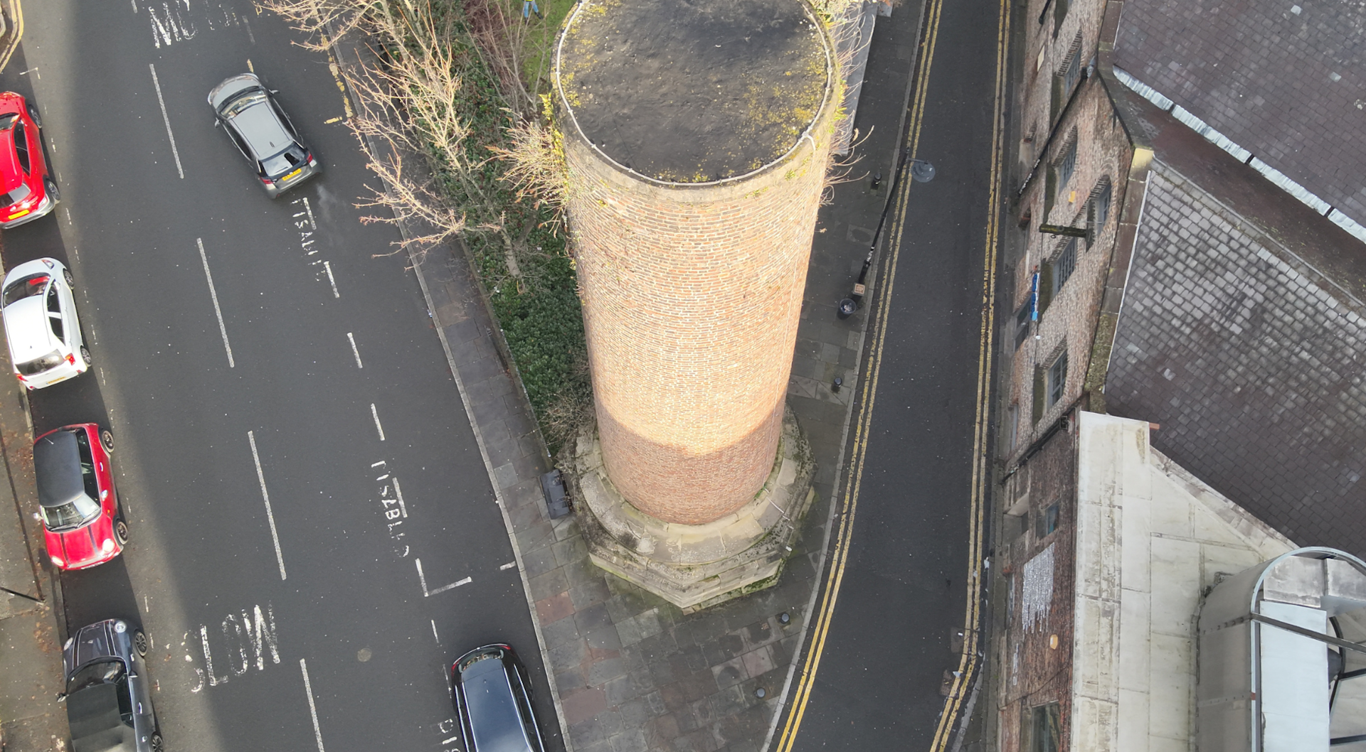
Another inspection they carried out with their drone was of the Ouseburn Chimney. Previously, this would have entailed two members of staff taking pictures from the ground level, which lacked finer details. Whereas now, with a drone, they were able to get an aerial view of the Chimney, providing higher results.

More applications include Newcastle City Council integrating drones into its security plan for the Great North Run.
The Great North Run, the largest half marathon in the world, occurs once per year and attracts people in the thousands, with 57,000 participants last year.
Previously, the security presence consisted of police officers and volunteers strategically placed on foot along the course. From now on, drones will monitor from above and send live reports to the officers on the ground for quicker responses, leading to a safer environment for everyone participating.
Lincolnshire Resilience Forum
Lincolnshire Resilience Forum has partnered with heliguy™ to utilise drones to streamline and better inform agency partners for more strategic and collaborative pre-and-post disaster response to incidents such as flooding.
heliguy™’s in-house geospatial team delivered survey-specific training to the Forum. This included showcasing a step-by-step drone photogrammetry workflow, using the DJI M300 RTK and DJI Zenmuse P1 camera to create this 3D model of Lincoln City's LNER Stadium.

3D models are highly detailed digital assets that provide realistic and accurate representations of their real-world counterparts. Georeferenced 3D models (such as the one we created) can be used for planning, analysis, calculations, and enhanced decision-making.
Sunderland City Council
Sunderland City Council has successfully employed drones for various operations, such as enhancing public safety and monitoring fly-tipping hotspots. Teaming up with Northumbria Police, they addressed community concerns regarding off-road biking disturbances at Fulwell Quarry by deploying drones equipped with facial recognition technology, resulting in arrests and a significant decrease in disturbances.
Neighbourhood Enforcement Officer Andy Proudlock, now a qualified aerial systems (UAS) pilot, said: “Gathering evidence and understanding how or where fly-tippers operate can take time, and the drones are helping make this work more efficient."
Expanding their drone deployment, the county council employs them to carry out surveillance of residential areas during Bonfire Night, aiming to prevent reckless behaviour and potential harm.
Councillor Kevin Johnston, Cabinet Member for Dynamic City, said: "Setting fires deliberately can have devastating consequences, leading to serious and, in some cases, life-changing burns. So this is all about keeping people safe.”
Monitoring with drones is more budget-friendly than sending out many officers and is a more efficient solution to locate illegal fires. Furthermore, it can detect illegal fires before they become more dangerous, meaning less harm to the local environment and residents.
UK Drone Training For Councils
With many purposes of drones eliminating hazardous tasks for people to carry out, there is concern this will mean people out of work; however, that is not the case.
Your workforce can be trained on how to use drones, and heliguy™ offers a range of courses that can train anyone from beginner to expert level. To view our drone training provisions please click the link.
Which DJI Drone Is Best For UK Councils?
DJI M350 RTK- Ideal for public safety, surveying, inspection and AEC.
The M350 RTK is DJI's most versatile commercial drone. Packed with many of the powerful features of the M300 RTK, the Matrice 350 RTK has some key additions to further improve the safety and experience of each mission.
DJI M350 RTK upgrades include an improved IP55 rating, enhanced video transmission performance, and an upgraded battery system.
DJI M30 Series- Ideal for surveying and roof inspections.
The DJI M30 Series packs much of the M300 RTK's power in a smaller, more portable frame.
These drones have an IP55 rating and are equipped with a 41-minute flight time.
The M30 and M30T have wide and zoom camera functionality as well as a laser ranger finder.
The M30T also features a thermal sensor with 640 x 512 resolution (perfect for roof inspections), route planning and the Smart Inspection feature.
The M30 series can also be integrated with the LP12 searchlight and speaker, helping to illuminate roof inspections in low-light conditions.
DJI Mavic 3 Enterprise Series- Ideal for surveying and roof inspections.
The Mavic 3E and 3T are lightweight drones weighing under 900g, making them significantly more compact than the previously listed drones.
The Mavic 3E is engineered for high-precision surveying while the Mavic 3T is tailored to RGB and Thermal data collection.
There is no IP rating for this model, making it unsuitable for harsh weather conditions.
These drones can be integrated with an RTK Module for enhanced precision. They achieve a maximum flight time of 45 minutes and benefit from omnidirectional sensing.
DJI Mini 4 Pro- Ideal for visual inspection, filming, and streaming.
The Mini 4 Pro is the most budget-friendly and lightweight drone of all the listed options.
Weighing under 250g, it’s portable and ideal if you plan to shoot content on the go or travel, placing it in the safest weight category. It means that operators do not require drone training (although we recommend this to enhance pilot expertise).
Combined with its compact size and user-friendly software, the DJI Mini Series drones are the most compatible with entry-level operators.
Though this model lacks some of the more sophisticated features of the enterprise drones, the Mini 4 Pro’s camera is perfect for shooting professional quality footage, with its 4k/60fps video, achieves 12MP / 48MP still images and records in 10-bit D-Log M and HLG capturing up to one billion colours.
Furthermore, it has a flight time of 34 minutes.
Conclusion
When it comes to meeting the needs of Local Authorities in terms of budget, accuracy and ease of use, drones are more often than not the most budget-friendly option.
As Newcastle, Sunderland, and Lincolnshire Resilience Forum demonstrated, drones have proven to be safer, faster, and cheaper than traditional methods.
Drones are revolutionising enterprise and the public sector with their ability to provide a safer, more efficient and cost-effective way to conduct inspections, surveillance, surveying, communications and many other applications compared to traditional methods.
If you are a UK Council looking to learn more about starting or scaling your drone programme, including proof of concept, hardware supply and training, please contact us.
